http://everything.explained.today/Oak_Hill_Park/
Compiled by Jonathan T. Melick
Oak Hill Park, 1952-1977
This story began in the late 1990s when I sat down at my old computer to record the story of my boyhood house at 6 Caulfield Circle in the Oak Hill Park neighborhood of Newton Centre, Massachusetts, while I was still able to remember the details, so that I could preserve the story for my future descendants. I added details about the other houses in my immediate neighborhood and about Oak Hill Park, to give the story some context; but as I wrote I realized that I was telling the story not so much of my house, but of Oak Hill Park itself. In the end, I decided to write two parallel stories, one with a detailed description of my house and my immediate neighborhood, and one which was more of a general history of “the Park”. Thanks to the advent of Facebook, I have read many other stories about the Park from many of my old contemporaries; and I have now incorporated many of them into this story. I have tried to list the names of everyone whose memories I’ve used at the end; and if I’ve left out any such names, I apologize – after all, we “children of The Park” are all getting to the age where we do get a little forgetful, now and then.
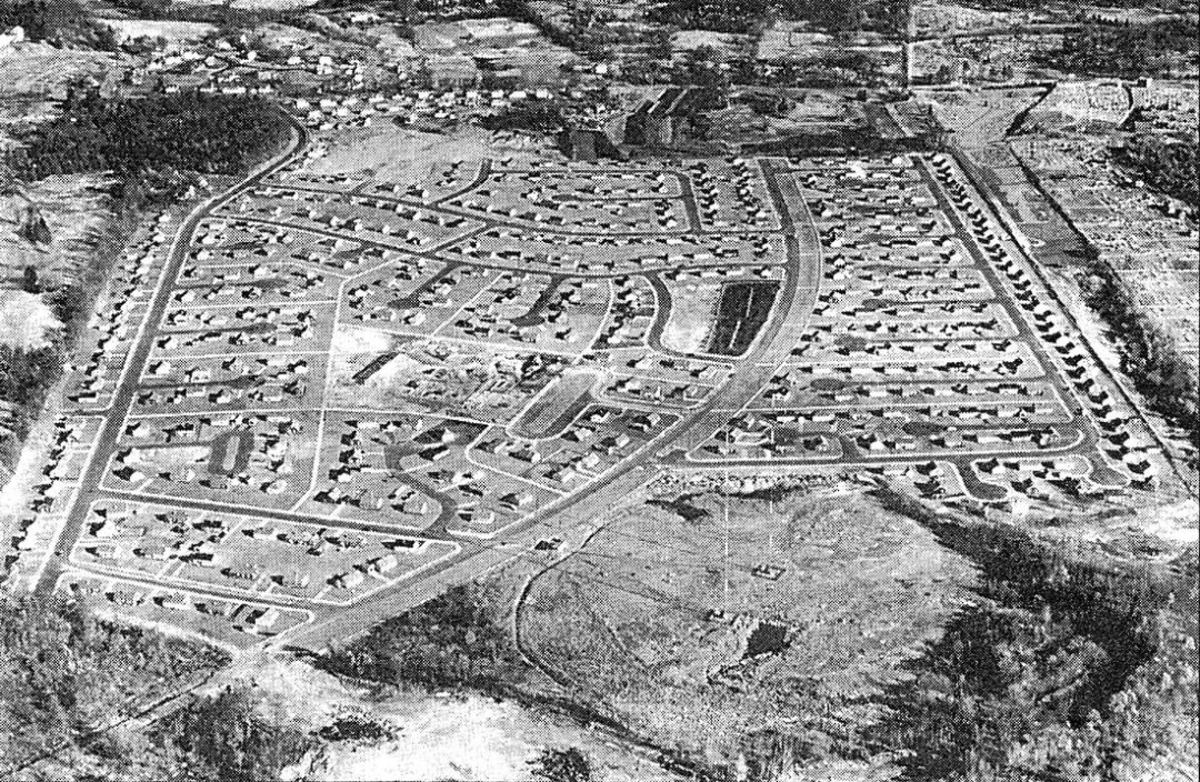
After World War II, many returning servicemen were anxious to make up for the time lost to their wartime service; and so, they married and fathered children who would become known as the “baby boomers”. These families needed places to live, and the existing supply of housing was inadequate. Eventually, the City of Newton decided that an area along the southernmost part of the border with West Roxbury, then composed of sand and gravel pits, farms, swampland, and glacial-terrain forest, would be transformed into a single-family housing development, with eligibility restricted to war veterans who had lived in Newton before World War II and their families. This area of Newton had historically been mostly farmland; and in 1903 only two houses stood within the future Park boundaries. By 1946, two more houses had been built, along with some barns and the Esty Farm store on Dedham Street. Wiswall Road ran in as far as the future McCarthy Road, and then continued down to around where Hay Road would eventually go. A swamp extended between the future sites of the160 block of Spiers Road, and Bontempo Road; and a dirt road ran in from where the cemeteries were through the site of the 100 block of Spiers Road; and a “swimming hole” was located roughly where Stein Circle would later be built. A sand and gravel business was also in the area, leveling the glacial hills and selling the glacial sand and rocks inside them.
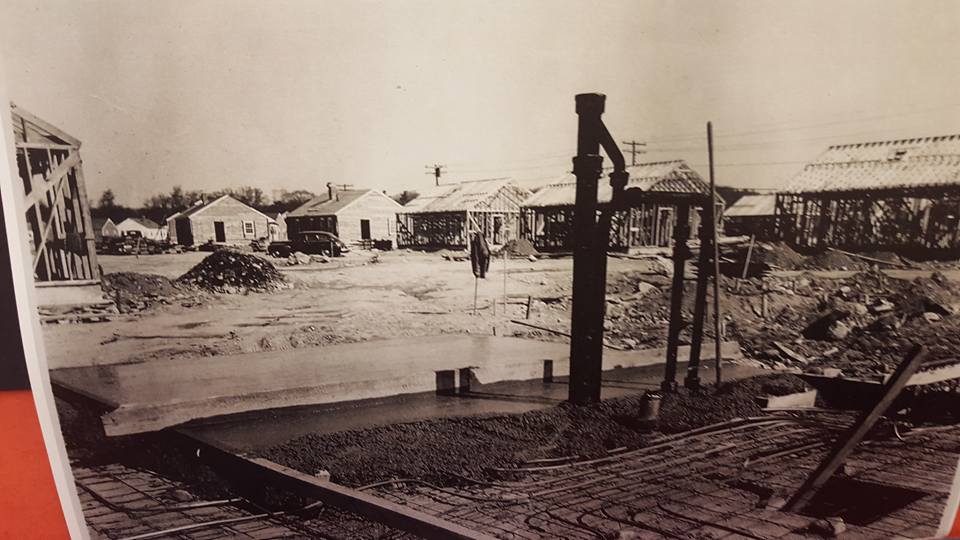
Work on the project began in 1946, with construction, in phases, beginning in 1948. Postwar shortages required the construction of a mill so that things like windows and cabinets could be manufactured on the site and installed in whichever house was ready to receive them. The first house was occupied on November 15, 1948, with a total of 73 being occupied by the end of the year, even though utilities were not functional until January of 1949 and the roads were not paved until the following month. By that point, 339 houses had been framed, with 219 needing only paint and final inspections before they too could be occupied. The streets were paved in the spring of 1949; and all 412 houses were occupied by September of that year. An article in the May 21, 1995 Boston Sunday Globe Magazine mentioned that there were 412 houses, with six standard models, all with three bedrooms. The “Basic House”, which included a living room, kitchen, bathroom, utility room and three bedrooms (one small, two large) on a concrete slab which contained the radiant heating system, cost $7,820. Cedar shingles cost an extra $319.00; cedar clapboards with gypsum sheathing cost an extra $247.00; a breezeway type porch cost an extra $325.00, and $1,250.00 if an attached garage was included. A detached garage cost an extra $925.00.
I have never been able to distinguish between more than two varieties of Oak Hill Park houses. One of them had a roof ridgeline that extended the full length of the house, and one had a hip roof at both ends. I also can’t identify those houses which were built with “extras” and which had them added later; and I suspect that, as in the case of my own house, people would buy a “basic” house and add other desired features as time and finances permitted, especially since the houses were designed so that later additions would be simple to build. Facing the houses, as they were originally built, the living room would be at the near left; the kitchen, at the far left, with the back door along the left hand exterior wall; the small bedroom, at the near center, to the right of the front door; the bathroom, at the far center; the utility room (holding the water heater, furnace, and often a washer and/or dryer), to the right of the bathroom; the second bedroom, at the far right; and the master bedroom, at the near right. The kitchens had built-in cabinets, above the sink to the right and opposite it, on the other wall of the kitchen to the right of the back door. Changes came to many houses, over the years; but even 25 years later, most Park houses kept this general layout.
The street system in the Park was similar to those in Levittown, New York and other so-called “greenbelt towns”. A grid arrangement had been contemplated, at one point; but the sentiment was that a greenbelt system would be safer and more attractive. There were several streets of normal type, such as Spiers Road, where the front doors of the houses faced the street; but many houses were built on cul-de-sac “Roadways”, with the rear of the house facing the street, and the front door facing a “Path”. For example, a person whose address was Van Wart Path might have the rear of the house, the driveway and the garage (if any) facing either G or H Roadway. This meant that a person who was looking for 10 Keller Path, for example, had to figure out which roadway permitted them to drive up to it. The reasoning behind this arrangement was that the housewives (remember, this was the late 40s/early 50s) could socialize together on their front lawns, and that other interactions between neighbors would be fostered; but I don’t remember seeing anything like this. Much of the social interaction happened in and around the roadways; and some families even remodeled their houses so that the main entrance faced the roadway. One advantage of the roadway/path system, though, was that the abutters did not have to deal with “through traffic” going past their houses.
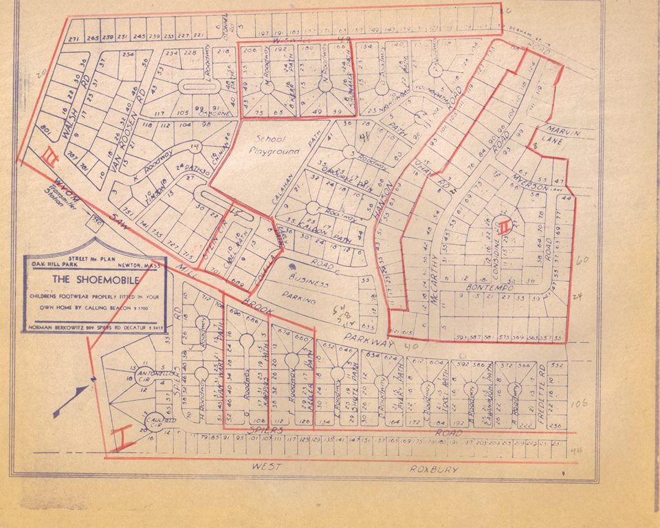
All Oak Hill Park streets were named after Newton veterans killed in World War II, with the exception of the separate developments in the area of lower Wiswall Road, Saw Mill Brook Parkway, which was originally intended to be a two-lane highway, divided by a grassy median, extending from Horace James Circle in Brookline, through the Park to the future Route 128; but due to community pressure was redesigned as a greenbelt boulevard bisecting the park lengthwise, following the course of a brook, now channeled into a culvert, which fed the “Stein Circle” pond, and had its outlet just beyond the southwestern end of the Parkway), and the upper Spiers Road/Esty Farm Road area. The only relics, today, of this proposal lie in the name, and the fact that the lowest house number, on the Parkway, is #551. The names were drawn at random; and those servicemen not honored with a street or path name were honored collectively by the naming of the Memorial School, with a commemorative plaque on a wall inside the main entrance. Easily the most curious street in the park is O’Connell Road, with only two houses on it. Why that dead-end road was built, instead of simply adding more house lots along Wiswall Road, I do not know; but perhaps there was thought of extending the road up into the Mount Ida Junior College campus, or else it was just to break up the solid wall of houses.
The Park was bounded by Dedham Street, the Boston city line, the woodland owned by the City of Newton along the Charles River (once part of the city’s water supply watershed), the property of Mt. Ida Junior College (as it was then named) and the houses of the Carlson Road area. Those houses which faced Dedham Street, except for the houses within the Esty Farm area, were not considered to be a part of the Park, although children living in them attended Memorial School. Around 1950, two areas comprising Indian Ridge Road and the parts of Wiswall Road, Marvin Lane and Myerson Lane closest to it, were developed separately. In 1953-54, Spiers Road area was opened up between Fredette Road and Dedham Street (there was once a barrier across Spiers Road just past the houses at #236 and #237, and Saw Mill Brook Parkway had them at both ends); and in 1958-59, the June Lane/Esty Farm Road area was developed (by Sumner Magnet, who lived on McCarthy Road). Although not part of the original Oak Hill Park, these areas were always considered to be a part of it when I was growing up. Within the boundaries of The Park, four houses remained from the old days: the Wiswall house (derelict after the early 60s, and demolished in the early 1970s), built in 1703, at the corner of Wiswall Road and McCarthy Road; a farmhouse on the Esty Farm, at 929 Dedham Street, built in 1700; a farmhouse at 75 Indian Ridge Road, which I will mention again later; and a house on a knoll just south of the Esty Farm (which is the only one of the four to survive today). The Esty family lived in an older house, just to the right of the entrance into their farm; but their house, like the house at 1005 Dedham Street, was never thought of as being within The Park.
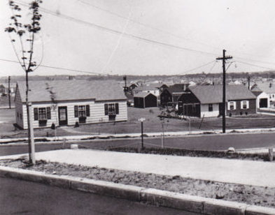
The Park was designed so that a family did not have to leave the Park for much. The City of Newton built the (war) Memorial School to serve the schoolchildren that soon flooded the Park, and a strip-mall shopping center was built along Saw Mill Brook Parkway, sometime around 1950. In the early days, it featured a gas station, barber and beauty shops, a toy shop, a dry cleaner, a drug store, a grocery store, and a branch of the Newton Free Library, along with one or two other stores. Even though most Park families had automobiles and could easily shop outside the Park, it was not uncommon for many families to do their shopping at “the Stores”. For us children, the Stores were a mixed blessing; we could enjoy the soda fountain at the drug store, buy a comic book or toy, buy a snack, or browse at the library, but we could also be collared by one of our parents and told to run an errand for them. Delivery trucks were also a regular sight. Back then, most milk was home-delivered in heavy glass bottles; and bread, fruit, vegetables and candy could also be bought. The very first Oak Hill Park map was sponsored by Norman Berkowitz of 209 Spiers Road, who ran “The Shoemobile”. He’d come to your house and fit the children there for shoes, and then bring the shoes on a later visit (how long that lasted, I don’t know; and my mother was never one of his customers. The most memorable deliverymen were Dom and Dutchie, and I’ll have more to say about them later.
We also had the Esty Farm. This small truck farm occupied a small plot of land accessible from Dedham Street, or from the circle at the end of Esty Farm Road, via a dirt road which ran through the property. Coming in from Dedham Street, there would be the Esty family house on a small rise, on the right, and a building straight ahead where the produce was sold. Some of it was grown on the agricultural land on the left and the rear of the lot, and other produce was brought in from the wholesale markets downtown. They also had an excellent supply of penny candy, ice cream and other goodies for us kids. A dirt road ran to the right of this one-story building, past a disused gasoline pump (probably dating from the 1940s or 1950s, and incapable of registering a sale greater than $9.99) and the 1700 farmhouse and garage. This road then swung to the left and passed a rough wooden structure, to the left of the road, which was used as a workhouse, which I’ll mention again later. The only other building which I can recall on the property was a Cape Cod house, derelict for as long as I remember it, at the foot of Indian Ridge Road (I believe that this is the house identified as 75 Indian Ridge Road on early maps of the Park). It was demolished by the early 1960s. To the left of the road, just before it met up with Esty Farm Road, was a small stock pond, where many kids went to catch tadpoles and frogs from time to time. One of the best-loved teachers at Memorial School, Miss Barbara O’Hara, remembers a pair of… um, “double-decker” frogs being brought into her class when they were studying the animal kingdom and reproduction.
The Oak Hill Park Association was formed in the early years of the Park, and functioned much like any other civic association. In the mid-1960s, for example, it bought some land at the end of Walsh Road and Saw Mill Brook Parkway to prevent construction of a road connecting the Park with the future Wells Avenue industrial park, which would have greatly increased outside traffic through the Park. They did a lot more; but as a kid, I noticed the things that were oriented towards my generation, such as the traveling fairs that stopped by every year, the annual Santa Claus motorcade (for us, this was an interfaith event; and almost everyone in the Park participated in it. The main qualification for playing Santa was not religious background, but suitable build), and the various youth groups which the OHPA sponsored. They also organized shows which were acted in by the adults (and any necessary kids) of the Park. In addition, they sponsored a “men’s softball league”, which was essentially an ongoing pickup softball game which happened on certain nights; and more than a few Park children entertained fantasies of being invited to join in a game. Their monthly newsletter was always interesting; it contained community news, a list of upcoming events, and the names of new OHPA members, among other things.
Memorial School was built for those children (later called “baby boomers”) who were already filling up Oak Hill Park houses. The school offered classes from kindergarten (morning and afternoon sessions) through Grade 6, and was located in Stein Circle, just a short walk west from The Stores. It was built, like so many contemporary schools, of yellow brick on the outside, with walls of glazed yellow face brick on the inside (the design was of the “International Style”), and was two stories tall, with a small one-story wing on the front, and a gymnasium wing on the back. On Mondays, Wednesdays and Fridays, classes ran from 8:30 AM until 12:00 Noon, and then from 1:30 PM until 3:30 PM. On Tuesdays and Thursdays, we attended classes only in the mornings (although if we needed “extra help” in a subject, a note would be sent home with us, telling our parents that we needed to meet with our teacher on those afternoons). Of course, the school had an active PTA which, among other things, advised our parents to question us whenever we got these invitations.
The main entrance was on the right hand side, so this is where I will begin my description of the school. Walking up the short flight of steps and through the green safety glass doors, we would see the school auditorium, with seats of molded plywood, on the right. Beyond it was Room 7, which was used as a classroom, a music room, and a kitchen. This kitchen was used mainly for functions held at the school, since in those days of stay-at-home mothers, none of the schoolchildren ever ate lunch at school. Straight ahead, looking from the main door, was the gymnasium. Entering the gym, on the left behind a pipe, one saw the flags used by Boy Scout Troop 50 (later 250) which met in the gym. Against the walls were hung the floor mats used during gym classes. Centered in the far wall were two doors for the storage room that held larger gym equipment. At each end of the gym were two 10-foot-high basketball hoops; and there were 9-foot-high hoops near the door and 8-foot-high hoops on the far end of the floor, for use in half-court games by the younger children in the school. From the ceiling were suspended several climbing ropes (which, with my keen athletic ability, bedeviled me until probably the 6th grade). At the far corners of the gym, as viewed from the main door, were two doors leading to the outside. A pass-through hatch allowed food to be passed from the kitchen into the gym.
The gym wasn’t just used for gym classes, though. As mentioned earlier, the Boy Scouts met there; but most Park children remember two “other uses” much more clearly. Whenever an election was being held, plywood voting booths were set up around the left side of the gym so that voters could mark their paper ballots (no voting machines!) in privacy. The League of Women Voters generally staffed the polls, meaning that many of the women in the Park could be found there on Election Day. Of course, children could not vote; but many of us would hang around the polls and cadge literature from candidates’ workers, and I suspect that this helped us get into the idea of making sure that we went to the polls when we were old enough to vote (and, when the age was lowered to 18 and I went to City Hall to register to vote, the voter register looked like a list of students at the Newton Public Schools during the 1960s!). Then, there was Halloween.
One night, after supper, we children would put on our Halloween costumes and head to Memorial School (I’m guessing that this didn’t happen on the actual Halloween, because I don’t think that anyone wanted to lose trick-or-treat time). We’d head to our classrooms for a Halloween party; and then when it was time, we’d head to the gym for the (shudder) Chamber of Horrors. This was set up by the parents of the Park; and we’d enter the almost completely darkened gym. We might climb up a home playground slide, and then get squirted at the bottom by one of the parents. We’d crawl through tunnels with various scary sights and sounds; and eventually we’d come out at the end, having thoroughly enjoyed the experience. I helped staff a couple of Chambers, when I was in high school; and around 1974 or 1975, I was asked to help staff a similar Chamber at the Spaulding School. Unfortunately, “safety concerns” (or overly skittish parents) mandated that the gym not be fully darkened and that nothing be done to risk frightening anyone; and I found this Chamber pretty insipid, compared to the ones I’d known at Memorial.
Leaving the gym through the main doors, there were some large windows on the right, and then the main corridor of the school. Immediately after turning right into this main corridor were some stairs leading to the top floor, and behind them a door which led to the playground in the rear of the school. The school office and nurse’s room were opposite it on the left. Just beyond the stairs was the fire alarm box, which I remember mostly from seeing the principal, Dr. Olive F. Eldridge, standing next to it during fire drills, and a small storage room. Next were some swinging glass doors, which were usually kept open. Beyond them were four classrooms, with Rooms 1 and 2 on the left, and rooms 6 and 5 on the right. Just beyond Room 5, on the right, was a corridor that led to the main rear doors to the school, built (like all of the other school’s doors) like the ones at the main entrance. A corridor on the left led to another set of stairs, another set of school doors, and to a smaller corridor which led to the kindergarten room and to Room 8, which may have been designed as a “nursery school” room since, just outside it, were boys’ and girls’ bathrooms with toilets much smaller than usual. There were small doors to the outside on either end of a small corridor separating Room 8 from the rest of the school.
Leaving Room 8, turning left, and leaving the school through the small door ahead, we would see a small black-topped area, surrounded by a tall chain link fence, which was used as a parking lot for the teacher’s automobiles. We children got to know that area best when, after school, the parking lot was empty and it could be used for games. Usually for me, these games had to do with the tall windowless wall that appeared between the windows to the kindergarten room and Room 8, and the Chinian Path end of the school. I don’t remember exactly how the games went, but they had something to do with throwing a ball up against the wall. Depending on how high the ball struck the wall, how far it bounced out into the parking lot, and whether or not it was caught, “base hits” or “outs” could be scored in an imaginary baseball game. This wall was also good for practicing one’s tennis skills. We also played these games at the other end of the school, against the blank auditorium wall, but here it was too easy for balls to bounce into the neighbors’ yards.
On the sides of the corridor leading to the rear of the school, there was a boys’ room on the right, and a girls’ room on the left. Reentering the main corridor from this direction and turning right, we would find the Custodian room (used by the custodian, Mr. Hayes, and his assistants, one of whom was Mr. Gorgone, and later Mr. Costa), and Rooms 4 and 3, on the right, the Kindergarten room on the left, another set of glass doors, and a set of stairs and small door at the end. The entrance to Room 3 was next to the foot of the stairs. Surprisingly, from the view point of today, none of these doors were ever locked during the school day; kids could enter the school through any of them; and, of course, there were never any security checks as we came into the building. Going up this last set of stairs, arriving at the top, and then going through another set of glass doors, there would be Rooms 13 and 14 (or was it 14 and 14A?) on the left, and Room 9 on the right (I’m not sure about the second-floor numbers). Past these rooms, on the right, was the school library; and on the left were some storage rooms and the boys’ and girls’ bathrooms. Just past the library were the stairs which led down towards Room 8. Beyond them, on the right, were Rooms 10, 11 and 12, and a smaller room used for occasional activities; and on the left were the Teachers’ Lounge, and Rooms 15 and 16. The stairs leading to the main entrance were beyond Room 16. There were some large glass windows leading to the outside next to these stairs, and the school staff (and the occasional misbehaving student) could get onto the roof from here.
I’m now going to imagine walking down this set of stairs to the first floor, and then retracing my steps to the corridor leading to the rear of the school. Leaving the school by the rear door, I would see some tennis courts on the left, inside a tall chain-link fence. These were flooded during the cold weather, and provided kids with an excellent skating rink (except that you had to dodge the posts for the nets). In the nicer weather, we could go to the tennis courts with a bat and some baseballs, and use them as a “batting cage” which made it easier to retrieve batted balls (unless one was hit completely over the fence, which given my modest athletic abilities took me quite some time to accomplish). Between the tennis courts and the school was a water bubbler set in a rough concrete base. This bubbler was only installed during the warmer months. In front of the door was a large blacktopped area, extending to the gym and slightly outward, which we used for playing around, usually before school but sometimes during school with our class. When I was in 5th grade. I remember Miss O’Hara’s fourth grade class painting a map of the U.S. on it (and the states of Utah, Colorado, Arizona and New Mexico “hosted” many a game of four-square). Next to the gym was a steel bike rack (no one ever used locks). Many kids rode their bikes to school, if the weather was good. There was often a light coating of sand on the blacktop near the door leading into the area of the office; and many of the older boys would sometimes ride once around the blacktop and then throw their bikes into a skid, near this door, to see how far around they could get the skids to extend. A complete circle, of course, was the ideal.
There was a large playground to the rear of the school. The main Little League diamond was in the far right corner, with a chain link backstop and two benches; but near the gym there were “cutouts” for bases, and a home plate, for other games (and I think that there was a third diamond near the tennis courts). In the far left of the playground was a set of swings (installed only in the warmer weather), some monkey bars, a “jungle gym” (built in the form of a cube, with a small cupola on the top and an “entrance” on the side nearest the tennis courts, built out of galvanized steel pipes. Next to the tennis courts were some large wooden tables, covered by a roof, known as the Shade House. During the school year, I don’t remember using these for anything important; and during the summer, it hosted a day camp so that the Park children could have something worthwhile to do (the rear entrance to the school, and the bathrooms, were open, but there was a gate which kept the rest of the school sealed off. The playground was large enough so that, if a game was underway on the main baseball diamond, something else could sometimes happen on the rest of the field without interfering with the main game. Except for a baseball “cap league” around 1961, I don’t remember any organized sports leagues in the Park when I was growing up. If you wanted to play sports, you grabbed the appropriate equipment for the season (baseball, in the spring and summer, football in the fall, and basketball now and then) and headed for the playground to see who else was around. In the winter, you got your skates, stick and puck and headed for any suitable ice surface.
I should also mention the basement and the roof. I was in the basement only once, as I recall, when Mrs. Turney brought her first grade class down there to see the kiln where our ceramics projects were fired. Also in the basement, in those days when the threat of nuclear war seemed to lurk uncomfortably close to us, was a fallout shelter where Park residents could presumably take shelter after a nuclear war made the Park uninhabitable. The existence of the shelter, and its capacity, were advertised on the front wall of the school near the main door by the customary black-on-yellow symbol with the “radioactivity” sign. Emergency food rations, and places to sleep, were brought up to date periodically. To warn us of an impending air raid or nuclear missile strike, an air raid siren was maintained on the roof. It was tested every Friday at 12:00 Noon, for one minute. Most of us kids knew that this was the “All Clear” signal, just as we knew that a warbling or rising and falling tone was the signal to take cover, and that a bright glowing ball in the sky, brighter than the sun and probably in a different part of the sky, was a nuclear explosion itself. In my earliest years at the school, we would have air-raid drills, where our teachers would give us a signal, after which we would sit on the floor, with our backs to the heating units and shelves which lined the outside walls, and cover our faces with our hands (protecting ourselves from blast effects and flash burns). The drills certainly did not continue past 1959, and at some point (probably the late 1960s or early 1970s), the siren tests were discontinued and the siren removed.
Unlike today, when school crossing guards always seem to be adults, the “Safety Patrol” which handled that job was formed out of members of the sixth grade. At certain designated points near the school, the “patrols” would stop traffic to permit the other students to cross the street in safety. There were several of these; but the only crossing points that I can recall were the ones where I performed my job, at the places where Cibel Path or McCarthy Road intersected with Sawmill Brook Parkway. Each patrol member would serve for one week, in rotation, and would wear a set of crossed white web belts over their torso, with a Safety Patrol badge (and not a cheap-looking one, either) at the point where the belts crossed over the chest. In the earliest days of the school, both boys and girls did crossing guard duty, and for more than one week at a time; but by the school year 1962-63, when I was in 6th grade, the girls would be responsible for escorting the kindergarten classes, in a group, to the various crossing points, and the boys would handle the crossing points, themselves, for all students. It was considered a prestigious job, and I don’t recall anyone ever declining to do it.
There were many different retail businesses in “The Stores”. Some, like an insurance agency, were less than memorable to me; but others I got to know extremely well. The Stores were one story in height, with a peaked roof which presumably served as space for storage and utilities. The building was built of red brick, with a black shingled roof. Several mock dormers were on the roof, and a cupola and weathervane marked the center point of the roof. Large red block letters marked the location of some of the businesses – I remember “BARBER” and “BEAUTY”; and I believe there was also “DRUGS”, “GROCERY” and “LIBRARY” there as well. At the northern end of The Stores was the library, in the spot once occupied by a nursery school. Next to it was the supermarket – tiny by modern standards, but it served the Park well while it was there. The first grocery store operated under the Market Basket name; but sometime around 1960 the Prime Food Mart, owned by the Bercheck family, moved in. Many of those Park families who did most of their food shopping outside the Park went there on a regular basis; and of course, many other families enjoyed the convenience of doing all of their food shopping there.
Next to the grocery store was the Oak Park Pharmacy, with Bill Stocklan as the pharmacist. I remember two things about the drug store which are completely absent from modern drug stores, the first being a display, on the right as one entered, which offered vacuum tubes for sale, so that, if a homeowner had a burnt-out tube in his radio or TV, he could test it on the display’s tester and buy a new one if necessary. The other thing was the soda fountain which ran most of the length of the front of the store, with its red Coca-Cola dispenser in the center. Of course, I often liked to get Cokes, or ice cream, there; and hot sandwiches, mini-pizzas, hamburgers and hot dogs were available (these were wrapped in plastic and heated in a small infrared oven – no microwave ovens yet!). Next to the drug store was, I believe, the insurance agency; and next to it was the Chiswick Cleaners dry-cleaning business. At the southern end of the building, beyond one or two small stores, were first the barber shop and then the beauty parlor. In a semidetached separate building, Ralph Prioli of Quincy, and his sons, ran an Amoco service station (where, during the 1974 gas shortage, we could leave our cars in the morning, on days when we were not supposed to be able to buy gas, and mysteriously find the gas tanks full by evening). They knew that we’d stop by to settle the bill as soon as we could. The air pump, to the right of the service bays and just to the left of the steps to the walkway in front of the stores, pumped up many an Oak Hill Park bicycle tire (and blew many of them out if we were careless about the air pressure). Of course, in those days, the air was available at no charge.
Characters and Fixtures
Oak Hill Park certainly had its share of “characters”. Many of us can recall the women, one who lived on Bontempo Road and one in the middle of the long section of Spiers Road, who were known for their eccentric behavior. There was also the man who walked, at a brisk pace, around the Park, wearing a suit and often holding a bag containing the toy soldiers that he’d just bought. The story was that he had been “shell-shocked” in World War II. Then, there was the man in charge of the workhouse at the Esty Farm, by the name of Roy, who would sometimes let the neighborhood children stop in for a visit, and sometimes invite them to write their names on a slat from a melon crate which would then be nailed to one of the studs of the building (when the building was being demolished in the 1970s, I recovered my slat, but discarded it when I left the park a couple of years later). Had I gotten to the building before the demolition began, and if I had had a place to store all of the slats, I might have saved more.
We also had people who came into the Park on trucks, with things to sell. In the nicer weather, several ice cream trucks would do an excellent business in the Park, with most of them selling soft-serve ice cream, fudgicles and the like. Almost none of us, I’m sure, remembers who drove these trucks; but almost all of us remember Dom and Dutchie. Dom was probably Italian by birth, and he drove a green Metro panel truck around the Park, selling fruits, vegetables, probably other grocery items, and (most important to us kids) ice cream and candy. In the early days of the Park, many families had only one car; and even so, it was not always easy for a woman with young childrenat home to go shopping outside her neighborhood. Having Dom come by, as he did (often in the afternoon) was a great help for us all. He stopped coming by sometime in the 1960s; and while I will not repeat the reasons for his departure here, I’ll just say that he was not universally beloved by everyone in the Park.
Dutchie (whose first name was Christian, and his Dutch surname began with an H) was either born in Holland or was the son of Dutch immigrants. He drove a delivery truck for the Hood dairy; and in a day when home milk delivery was nearly universal, Dutchie had many of the Park families as customers. He would deliver our standard order to our houses, and he had the full selection of Hood dairy products available if desired. If no one was home, he would leave our usual order inside the back door or, most often, in an insulated, galvanized milk box. Of course, the milk bottles were glass, embossed with the Hood logo, and the lids were of stiff waxed paper, with a cardboard “button” that identified the contents and tightened the seal. If we children were around when Dutchie was delivering, we would often escort him around our neighborhood (sometimes beyond), on our bicycles; and sometimes, we were treated to a ride in the truck. He kept his inventory cool with blocks of ice, and we kids could occasionally get a chip or two from him.
There was also Menashe, the barber. Even those who got their hair cut elsewhere remember him standing outside his shop, if he wasn’t busy, asking “ya wanna haircut?” in his heavily accented voice. He was known for the selection of magazines that he would offer, as reading material, based on the age of the customer and who else was in his shop. I don’t recall ever getting my hair cut there; but I had friends who did, and I remember the style chart on the wall behind the barber chairs. This memory has to be from the early 60s, because one of the styles was the “JFK”. Menashe’s accent indicated that he was of foreign birth; and the tattooed number on his arm indicated that his life had once been much more unpleasant than it was when we knew him.
Of course, each Oak Hill Park house had an interior arrangement which was almost identical to that of its neighbors, when the houses were built; but over time, the owners of each home tailored that arrangement to their own requirements. What I’d like to do now is describe the arrangements of the homes, in Caulfield Circle, which I knew the best, as a way of illustrating a typical neighborhood within the Park.
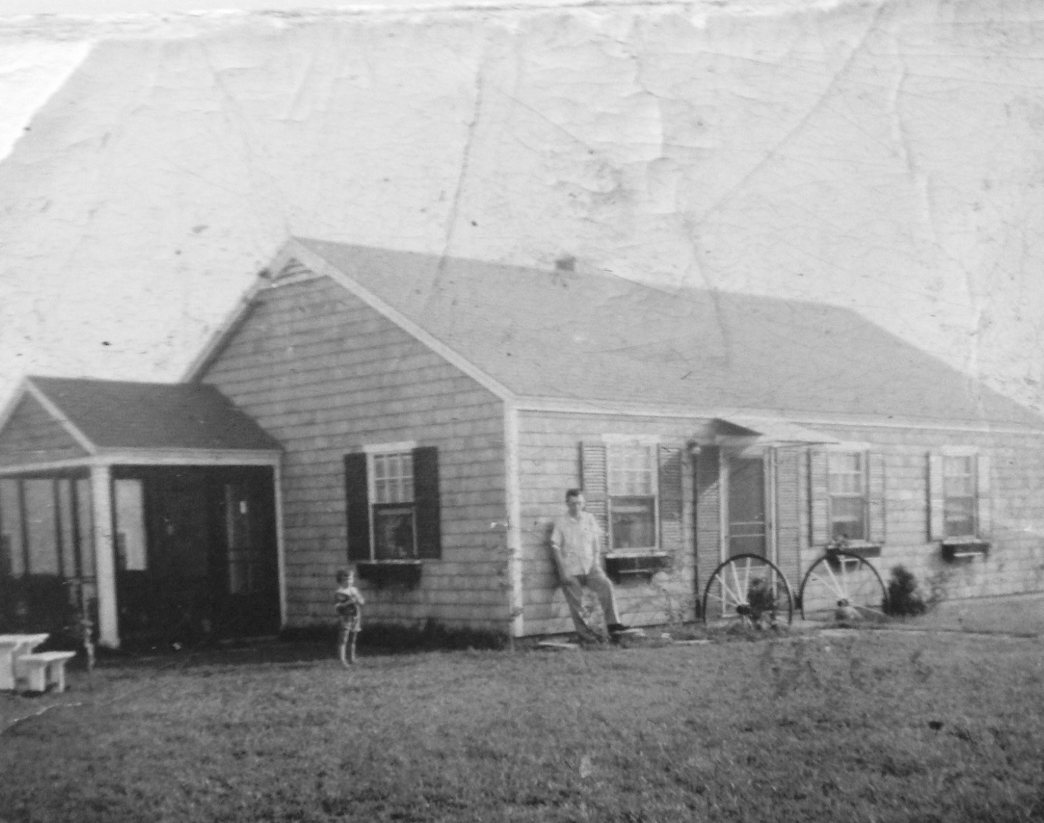
The Irwin house, at 73 Spiers Road, acquired two additions, shortly after it was built (the men of Caulfield Circle did the work, under the supervision of Dave Irwin, a carpenter by trade). Mr. Irwin built a garage/workshop off of the left end of his house, with a small pantry connecting it to the main part of the house. He also added a family room, with a fireplace, off of the kitchen, and built a small playhouse (which we all called “the Hut”) for his children. After the foundation was dug for the family room and before construction began, a sort of swimming pool was improvised for the neighborhood children. My own house, at 6 Caulfield Circle, soon acquired a garage, in the far corner of the lot near the Irwin property; and by arranging for leftover concrete from many nearby jobs to be poured there, my father was able to have a concrete floor, in the garage, that as he put it, “could support the weight of a tank”. An addition was built on the side nearest the Irwin property, around 1955, to hold an expanded living room and also a dining room. A shed was added, along the back of the back yard, a year or two later. The “Gorodetzky house”, at 12 Caulfield Circle, probably kept its original arrangement throughout my time in the Park, because no one who ever lived in the house felt the need to add onto it while they lived there (an addition was put onto the eastern end after I moved away). There was a small shed, centered along the rear of the property, which dated from the early 1950s.
The Spilman house, at 16 Caulfield Circle, acquired an addition on the left side of the house, soon after it was built, and this became the living room, into which the new front door opened. Shortly afterwards, the house acquired a family room off of the kitchen. A shed was added to the left of the house in the 1960s. The Wheeler house, at 20 Caulfield Circle, may have been built with the breezeway porch which it had along the left side of the house; but I can’t be sure. As for the rest of the house, the arrangement was probably a standard one. One feature which I remember is that a dog had walked across the freshly-poured cement of the walkway leading to the back door; and as far as I know, those prints are still there. The Caulfield house, at 15 Caulfield Circle, was probably one of the Park houses which had its attached garage and breezeway built along with the rest of the house. The kitchen had a breakfast nook along the back wall. The Caulfields had three sons, so the oldest son had the small bedroom while his two brothers shared the second bedroom. They had a small storage shed along the back wall of their property. From 1953 until 1965, the house was owned by the brother of the man for whom the Circle was named.
I don’t remember much about the Lee/Goldstein house, at 65 Spiers Road, or the MacNeil house at 57 Spiers Road. I do know that the Lee house, as far back as I can remember, had a detached garage which, unlike the house, faced onto Caulfield Circle. The MacNeil house had a breezeway porch where mine had the 1955 addition, and a detached garage in the far left corner of the property. The Santucci house, at 70 Spiers Road, had a single-car garage, connected to the house by an apparent breezeway, as seen in an aerial photo from 1950; but by the late 50s it had been further modified in a way which I do not remember seeing in any other Park house. The main part of the addition was at the rear of the house, which now had a second hallway parallel to the first. Each of the Santucci daughters had her own bedroom, and there was a second bathroom as well. The old second bedroom became a den; and I don’t recall what became of the old small bedroom. An attached garage was accessible from the kitchen.
There were other similar neighborhoods throughout the Park, with one example being the one centered around the intersection of Considine and Bontempo Roads. The neighborhoods closest to Caulfield Circle centered around H Roadway and Antonellis Circle; and of these two, the people of Caulfield Circle were closer to the people in Antonellis Circle. Many of the adults and children knew each other and would do things together; and we would all occasionally cut across the Chiappisi property, on the far end of the circle, to get to the woods in back; but it was still a different neighborhood. Coming from the MacNeil house, the first house was the Karp house; after that was another house belonging first to the Dana family (they had a daughter, Vivian; and they moved away when I was very young), and then the Stevens family (they later moved to Walnut Street, near Newton North High School). Next were the Chiappisi. Bell/Saxe, Zeidman, and Deschenaux/Levine/Shapiro houses. Of the children in this neighborhood, I best remember Ralph Saxe, Laura Zeidman, and Dottie (later Dotte) Levine, since they were my age or close to it; but there were other children here as well.
One of the best things about growing up in Oak Hill Park, in the early years, is that there was always plenty to do. If one of us wanted to find someone to play with, we could just walk around a bit and find someone, or else head up to Memorial School and see who was around. Often, we could find someone in the Roadway or Circle nearest our house, and play ball, hopscotch four-square, or whatever was agreeable to everyone. More than a few of us were sent outside, after breakfast, and expected to stay outside until lunch; and after lunch we would go back outside until suppertime. If we didn’t have school, the following day, and the weather was good, it wasn’t unusual for us to head outside and play until it was almost time for bed. There were rarely any structured activities for us, but we couldn’t have cared less – we did just fine coming up with our own things to do. To be perfectly honest, some of those activities were things that our parents, and perhaps the police, did not want us to do, especially as we got older; but in general we did not get into too much trouble. Of course, though, where one played or hung out the most often depended on where one lived; and so I’ll start this section with a description of my primary childhood haunts.
In back of the Spilman, Wheeler and Caulfield houses were “the Sandpit” and “the Woods”. The glacial topography of the two areas, on land bordering the Charles River, was left largely untouched when the Park was built, except for some areas immediately abutting house lots that were cleared for staging areas and gravel borrow pits. One of the cleared areas was behind the Spilman and Wheeler houses, and consisted of a small glacial esker (hill), with a “kettle hole” behind it, overlooking a grassy field. The esker was known to us as “Sandy Hill”, and the general area as “the Sandpit”. Other kids from other Park neighborhoods played there, but since there was no public access except through property on lower Spiers Road or upper Saw Mill Brook Parkway, other kids had to cut across someone’s yard to get to the Sandpit easily, and it was mostly the kids from Caulfield Circle, Antonellis Circle and their friends who played there. We used the Sandpit for many different things, whether it involved sledding and snowball fights in winter, digging in the sand during the other seasons, or just plain fooling around.
Both the Sandpit and the Woods gave us all an incredible variety of places to play and things to do. There were rocks which we boys turned into rockets, ships or cars; three ponds (Big Monster and Little Monster, near the cemeteries, and Commando, off of the short end of Spiers Road) where we could skate in winter, hunt for frogs or turtles, or just get good-and-stinking-dirty; and dry, hilly woodlands where we could go exploring, refight battles of World War II or the Korean or Civil Wars, or keep the Communists (Russians; the Vietnam War had not yet reared its ugly head, in our perceptions) away from our homes. The girls came up with plenty of things to do there, as well. There were two radio transmitter towers in the Woods, just north of Commando Pond. These towers were used first by WVOM, at 1600 kc (back then, radio frequencies were still stated in kilocycles, not kilohertz), and then by WBOS and then WUNR, on the same frequency. Most Park kids remember the way that we could hear WBOS through the telephone, on pipes, on toasters… and on the fillings in our teeth, went a common joke. Of course, we could not play on the towers, but we could play near them (and occasionally, we bravely sneaked inside the surrounding fences). The towers were a local landmark; I saw them every time that I left my house; and in 1973, when I was flying into Boston for Christmas, after dark, I used the towers to find the lights of my own home, which was easy to do because of the cemetery and woods which bordered Caulfield Circle.
A long road, which we called the Army Road since parts of it were built by the Army to provide access to the antiaircraft batteries which were once located near Kendrick’s Bridge over the Charles River, at Nahanton Street, extended from the bridge past land owned by the Charles River Country Club, Mount Ida Junior College, and the cemeteries in West Roxbury, as well as the Park, until a junction with a road from Gethsemane Cemetery to the West Roxbury dump, near the Monster ponds. This land had once been the property of the old Newton Water Works, which supplied water to Newton Corner and Nonantum, and had filter beds and a pumping station in Newton Upper Falls, off Needham Street. This supply was abandoned when water from the Quabbin Reservoir became available to the Greater Boston area. Kendrick’s Bridge had once been built of wood; and just before crossing the Charles River, Nahanton Street had once dipped down to the right to make the crossing; but the modern concrete-and-steel bridge which replaced it around 1960 followed a higher and more direct route across the river.
The pilings of the old wooden bridge were not all removed, though. In the 1990s, a cleanup of the river in that area was made; and although the water was not clear it was swimmable, and a special swim day was held. I fulfilled a long-held ambition, that day, when I went swimming there; and as I swam towards the bridge I encountered some of the old pilings, about five feet below the surface of the water. A section of this road had once led into the future Oak Hill Park, from near the Monster ponds; but by the time that I first discovered it the road was already well overgrown, in those spots where the cemeteries and the Park had not obliterated it completely. The road had once been accessible from Saw Mill Brook Parkway, but a barrier closed that route off when the Park was built. The other parts of the roads were kept open so that the fire department could have access to the woods in case of a brush fire, several of which I remember happening. When a business park was built on the northern part of this property in the mid-1970s, the new Wells Avenue obliterated this road until just short of the cross road which led down from Mount Ida to a wooded point overlooking a bend in the river. Some of the roads had been old farm roads, because they were lined with rocks and stones that a farmer would have cleared from his fields.
Of course, there were plenty of trees where we could build tree forts (which were usually vandalized before very long); and there was the Boston city dump in West Roxbury, close to the VFW Parkway (US Route 1, at the time), which provided us with the raw materials to build various things and with other varied “treasures”, most of which were thrown out by our mothers when our backs were turned. Once in a while, an automobile would be abandoned in the Woods; and in contrast to what would happen today, the autos would often remain in place for weeks or months. We kids treated them as a sort of “found treasure”, and we thought nothing of picking them apart (odometers were particularly prized). There were also some Concord grape vines near the Monster ponds; and sometime in the mid-50s, the Irwin, Melick and Spilman families went into the Woods, picked the grapes, strained out the juice, and made grape jelly from it (which I considered to be a waste of grape juice, although I certainly liked the jelly). The discarded grape skins were tossed into a corner of the Irwins’ back yard, and it was from the grape vines which sprouted from them that Jim and I got the grapes to make a batch of pretty good Concord grape wine in the summer of 1976. There were also a lot of blueberry bushes; but by the time that I was old enough to be in those parts of the Woods by myself, I was spending my summers elsewhere and never did any berry picking there.
There were wild animals in the woods, as well. Pat Hurley, formerly of 79 Spiers Road, recalled seeing “a sox” – i.e., a fox – one day when he was little. There were plenty of birds, rabbits, chipmunks and turtles, including the snapping turtles which would sometimes come out of the woods into the yards of houses on Caulfield and Antonellis Circles or Spiers Road (and then get shot by the police, since picking them up was extremely dangerous because their jaws could easily bite off a finger or two). I don’t remember any deer, back then; but that may because any deer which had lived in the area had long since been hunted to extinction or had lost their habitat. Now, the woods have grown back to the point where deer and coyotes are not rare.
One summer during the early 1960s, the Army Corps of Engineers went into the swamps near the dump to dig ditches to drain them, as a mosquito control measure. I came home from my grandmother’s summer cottage, where I spent most if not all of my summers through 1968) to find a new source of enjoyment underneath a gravel road that led to the dump: “the Culvert”. It allowed one of the new ditches to cross under the road, and flowed into the Charles River. Carp and turtles loved the ditch, and we boys had a lot of fun there. Once, we took the top off of a washing machine which had been dumped in the nearby woods, and used it to seal the culvert, because the men who did the dirty work at the nearby cemeteries had gotten us angry at them, and we wanted to cut them off from their flower dump at the end of the road. We succeeded in flooding the marsh on the upstream end of the culvert, and we were able to wash out the road. As of January 2012, the washout had never been repaired.
There was a Catholic cemetery that ran parallel to Spiers Road, just over the West Roxbury line. The cemetery extended as far as the property lines of the corner of the Park, and there was a puddingstone wall running all along its length. A puddingstone wall divided the backyards of the Park from this cemetery; and hemlock trees helped to screen the cemetery from view (both of these were put in place as a condition of extending the cemetery in the mid-50s). Some years later, an extension of the wall was built, capped by flat, roughly-dressed stones; and Jim Spilman and I used to use this area, during various spring thaws during the mid-1960s, for “the Waterworks”, meaning that we used to play with the flows of water from the melting snows (without getting too wet, our mothers hoped). We also would play in the cemetery itself, or in the Jewish cemetery that abutted it to the east (I think that, since we were so used to it, we didn’t get the creepy feeling that we otherwise might have gotten). Often, we would continue on to Pulpit Rock, near the northern end of the Jewish cemeteries, located just east of the Catholic cemetery, where the colonial preacher John Eliot was supposed to have preached to the local Indians. There once was a bronze plaque commemorating the events, but it was certainly stolen for resale as scrap, by the end of the 1960s. We kids loved to climb the rock, and squeeze through the various passages (who can forget the “lemon squeeze” and the small cave inside the rock – at least, until increased size made that impossible! The historic Brook Farm was a short distance away, but we kept away from it because it was used as an orphanage until well after the Circle kids were all adults. More than a few Oak Hill Park mothers were surprised when their child or children presented them with a bouquet of flowers – raided from a display left at a graveside after a funeral.
For those Park children who spent all or part of the summer, there was plenty to. In addition to what we did in the spring and the fall, there was the day camp at the school, field trips to amusement parks (Norumbega, Paragon, Lincoln, Whalom, Canobie Lake, and White City were all within driving distance), family trips to lakes and the ocean, and much more (including “unauthorized” visits to the pool at Mt. Ida, at night, after closing time). There was also a Fourth of July parade, and much more. Many neighborhoods had outdoor barbecues on summer nights; and the Red Sox (and, through 1952, the Braves) welcomed many an Oak Hill Park baseball fan. Wintertime, of course, provided us with a whole different set of activities to enjoy. I don’t ever remember seeing anyone on skis or snowshoes, while I was growing up (except for those which my father had, in his garage, but never used); but almost all Park children owned a pair of ice skates. Many would go skating at the tennis courts near the school, which I described earlier; but living so close to The Woods my neighbors and I, and our friends, often headed to one of the ponds to skate, as soon as the ice was thick enough. Most of us also had sleds, “flying saucers” and the like (toboggans were scarce). Sandy Hill, Mt. Ida, and the golf course along Nahanton Street were the prime locations for sledding. We all became good at building snow forts, especially if snow plows gave us a tall pile of snow to build one in; and sometimes, we would build elaborate forts with tunnels, passageways, parapets, and “snowball bins” for our “reserve ammunition” during snowball fights, or else we would build networks of smaller forts to provide effective crossfire against our opponents (often a group of kids who walked around looking for a snowball fight).
One recreation which seems bizarre, especially by today’s standards, involved riding one’s bike behind the “bug truck”. In mosquito season, the City of Newton would send trucks around which burned a mixture of oil and insecticide, and sprayed the resulting clouds of smoke around the Park. I can remember hearing the approach of the truck, as I helped my parents close the windows of our house so that the smell (or, at least, most of it) did not stink up the inside of our house. For some reason, more than a few Park children would run for their bicycles, and then ride along behind the bug truck, inside the cloud of smoke. Many of us joke, now, that it’s a miracle that we did not get sick and die, and have children of our own who had two heads, six arms and so on. More “conventional” bike rides were encouraged; and most Park children remember the day that everyone rode their bike to school so that Officer Feeley could teach us about bike safety and then take us on a short bike ride (later, Officer Bobby Braceland would park his cruiser near the Friendly’s restaurant, in Chestnut Hill, to keep an eye on those Newtonites with access to cars. He was concerned for our safety – but that concern was unappreciated, of course, by those he stopped for some violation or another.
Living on the southernmost side of Oak Hill Park, I naturally gravitated to the woods nearest Caulfield and Antonellis Circles when I wanted to play in the woods. However, the kids who lived on the northernmost side tended to do more in the woods bordering Mount Ida Junior College. This two-year college, founded on Mount Ida just southwest of Newton Corner, had moved to the old Robert Gould Shaw II estate, just north of the future Park site, in 1939. When I first remember it, it admitted only female students; but now, it is a four-year college which admits both men and women. The part of the campus bordering the Park was open and grassy. I spent some time up there, in other seasons, with my friends; and as long as we didn’t bother the students or damage anything, our presence was tolerated (now, if one wishes to drive onto the campus, there is a guardhouse barring the way). I never dated a Mount Ida student, since by the time that I returned to Oak Hill Park, after college, in 1974, I was in a relationship with my future wife; but more than one guy from the Park dated a Mount Ida student, and there were a few marriages from these relationships. The campus could be seen from either side; and apparently some of the young men who lived on Nahanton Street would take binoculars and telescopes, when the leaves were off the trees, and observe the women, in their dormitories while they… took care of business.
In the early years of the Park, many of the children who lived there had some contact with one of the various Scouting organizations for boys and girls. Cub Scouts, Brownies, Bluebirds, Boy Scouts, Girl Scouts and Camp Fire Girls (the last three being the older levels of the first three) all had active units in the Park; but participation in the older levels tended to drop off once their members reached junior high school. Many factors entered into this; but one of the main reasons was that the younger levels were based on activities which took place in the afternoons, in and around someone’s home or the school (and many kids wore their uniforms to school on meeting days). The older levels met in the evening, when conflicts with family or school activities or requirements were more common; and for many kids, there just wasn’t enough of interest to keep them as members of their troops. I can’t address this issue directly as it pertained to Camp Fire Girls or the Girl Scouts; but I do know that the Boy Scout emphasis on camping, hiking and the outdoors meant that the majority of Cub Scouts who crossed over to Troop 250 from Pack 250 did not remain with the troop for long. Those who did stay, though, were in for a very enjoyable experience. I was never a Cub Scout, partly because only one of my friends was a Cub and partly because my father, a veteran Scout and Scout leader, didn’t think much of Cubs; and when I was old enough for Boy Scouts, the Park’s Troop 50 had collapsed. It was only because my next door neighbor, Davy Irwin, revived what became known as Troop 250 that I joined the troop in late 1964; and even then I joined mostly because many of my friends were founding members.
Today, if anyone took a firearm and went into the Woods to do some target shooting, the Woods would be swarming with police in a flash, and the shooter would soon be face down and in handcuffs. In the first years of the Park, though, it was not unusual for those living near the Woods to hear gunshots; and we thought nothing of it. I did not own a firearm, myself; but I knew people who did, and sometimes I was allowed to plink at cans or bottles with them, often at the West Roxbury dump. If the person with a gun was someone we didn’t know, they’d often let us watch as they shot, as long as we stayed out of the way and didn’t make any noise. Bruce Spilman and his family even used to shoot skeet from their backyard, in the direction of Sandy Hill (and, being a responsible firearm owner, Bruce and family would make sure that no one was anywhere nearby). My paternal uncle also recalls using his .22 there, and also in the gravel pit through which Route 128 was built in the 1960s; but he felt that, as an ex-serviceman, no policeman was going to give him a hard time as long as he was careful how and where he did his shooting. As far as I know, no one did anything stupid with their guns, such as vandalism (except for maybe wanton killing of animals); and I don’t remember any violence or accidents.
Of course, we had radio and television to entertain us. The biggest radio stations (AM, of course, until the mid-60s) were WEEI (590 kHz), WNAC (680 kHz), WHDH (850 kHz), WBZ (1030 kHz), and WMEX (1510 kHz). I don’t remember which was the most popular, or what the formats were; but most likely they featured DJs who were also what we’d now call “on-air personalities”. WHDH broadcast Celtics, Bruins and Red Sox games (what they did when two teams played at once, I don’t remember). The only exception was WMEX; it was Boston’s first “Top 40” rock and roll station, featuring the legendary DJ Arnie “Woo-Woo” Ginsburg. Norm Ruby, of the Park, was a classical DJ on this station, as well. There were other stations of lesser importance; and the most memorable of those was the one at 1600 kHz, which I mentioned earlier. It broadcast mostly “ethnic programs”, so although we could easily get its broadcasts, almost no one in the Park listened to them. However, since it was literally so close to us, it deserves a paragraph of its own.
In 1948, radio station WVOM was established, with studios in Brookline. At first, it broadcast what is now known as “beautiful music” (think “elevator music”); and it was one of the first radio stations to broadcast around the clock, seven days a week. It became WBOS in 1955; and in 1958 it switched over to “ethnic” programming. Before then, though, Arnie “Woo-Woo” Ginsburg had gotten his start on WBOS, before switching over to WMEX. The station became WUNR in 1976 (standing for “We’re the United Nations of Radio”). The original transmitter towers were a pair of tall towers, supported by guy wires. They were painted red and white, and had red lights (some steady, and some slowly blinking), so that nearby aircraft could spot them (and, around Christmas of 1973, the towers helped me to spot the Park and the lights of my house as my airplane was heading in for a landing at Logan Airport in Boston). The towers were replaced, in 2007, with five smaller, unlit towers; and in contrast to the old towers, which carried only WUNR’s programming and radiated 5 kilowatts of power during the day and 1 kilowatt and night, the new towers radiate 20 kW of power around the clock, and also carry the programs of two other stations (this increase was opposed by some, who feared the effects of the increased radiation). The building on Saw Mill Brook Parkway, at the foot of Van Roosen Road, is equipped with a studio but is essentially a housing for the transmitters.
As for television, the big channels were WBZ (channel 4), WHDH (channel 5) and WNAC (channel 7). WGBH (channel 2) was the “educational station”; and most Park children, at one time or another, listened to its daytime programs while in class – usually, we’d listen to the program, and then do something based on what we’d just watched. WTIC (channel 3) in Hartford could be watchable, once in a while, as could WMUR (channel 9) in Manchester, New Hampshire. WJAR (channel 10) and WPRO (channel 12) were easily watchable, unlike today. Later, in the 60s, WLNE (channel 6, in New Bedford) and WNHC (channel 8, in Hartford) came on the air; but they were rarely worth the effort to watch. UHF channels first appeared in the 1950s; but UHF never became established until TV manufacturers were required to include UHF tuners in their sets. WIHS (channel 38) was the first in the Boston area, followed by WKBG (channel 56), WXNE (channel 25) and WGBX (channel 44; it was an educational station like its sister WGBH). Channel 27 in Worcester, replacing the former Channel 14, also appeared in the 1960s, and could be received in Boston. Cable TV, back then, was unknown to us.
The Park also created its own cultural enrichment. More than one Park child studied music with Mr. Napoli, or Mr. Neiger, at Memorial School, or studied piano with Mrs. Garber or Mrs. Maxner. Memorial School had its own orchestra, which produced music for school events. Various community theatrical and musical productions were put on from time to time, including Tom Sawyer and the Wizard of Oz. There was at least one fashion show; and one afternoon Marty Caulfield and I sat outside the beauty parlor and watched women run out of the parlor, hair freshly dyed green or some unusual shade, and hoping to hide their new color under a scarf until they were safely in their cars. Memorial School also produced various performances for the benefit of parents and family; and at least once the students who were studying French put on a French-language performance. How much of this the parents and families understood, I don’t know – either they were given a script and translation, or else they just enjoyed hearing us speaking serviceable French.
As we got older, many of us used our extensive knowledge of The Woods to enjoy drinking various beverages that we were still too young to drink legally, smoke (sometimes tobacco, and sometimes something else) and pursue various fleshly recreations with an intimate companion. We were often joined, in these activities, by kids from other neighborhoods, since they did not have woods close to their neighborhoods like we did. More than once, I remember seeing plywood shelters being built, or crude log cabins, to provide a space for these activities that afforded the participants shelter from wind, rain or prying eyes. All of these eventually burned down (both accidentally and deliberately) or were removed by adults and the police. Sometimes, as we walked through the woods, something like a skirt, some underpants, or some other item of clothing might appear in our path; and we would speculate as to who left those things there, or try to remember who we’d seen wearing what we had just found. There were also inter-neighborhood rivalries; but except for kids from West Roxbury (including Chris Nilan, who later played in the National Hockey League), I don’t remember these rivalries turning violent.
The Darker Side
Looking back at Oak Hill Park, many people who grew up there view the Park as idyllic; but the Park did have its darker side. Social ills such as crime, alcoholism, infidelity, substance abuse, which seem so relatively prominent today, existed in the Park but were kept under wraps. For example, someone who was well known to many of us became known for taking indecent liberties with more than one young girl in the Park; but the subject was discussed only discreetly, if at all; and many people only learned about these incidents only in recent years. As far as I know, this person was never prosecuted, but only compelled to stay away from the Park. Several Park children had to deal with serious illnesses or disfigurement; and more than a few of them passed away at much too young an age. More than a few boys who “played Army” in the Woods wound up in the real U.S. Army; and several served in Vietnam, with at least two (Bobby Steinsieck and Paul Dunne) being killed in action, and others eventually dying from injuries or illnesses encountered there. In the 1960s, some struggled, more than others, with the social pressures of the time; and drugs took their toll on more than a few of us. As for crime, unfortunately more than a few Park children used knowledge gained through earlier friendships to target homes for burglaries. Some Park families were able to afford to hire outside domestic help; and more than once this outside help passed along information on valuable items to less welcome outside visitors. More than a few Park houses experienced fires; but as far as I know none was ever fatal, or produced any serious injuries. I don’t remember any ethnic or religious incidents happening within the Park; but one Yom Kippur, someone decided to desecrate part of the Jewish cemetery in West Roxbury. Newton and Boston police collaborated in the effort to find those responsible, and Joanne Spilman Kilduff recalls that the Newton Police command post for the incident was in the Spilmans’ back yard.
By the 25th anniversary of the Park, in 1974, the Park had undergone significant changes. Many of the original families had moved away, and many of the children who’d filled the Park during the 50s and 60s were either away at school or had moved out and were on their own. Most original families saw much less of each other than they had seen in years past; and even so, there was now a heterogeneity to the Park that kept the newcomers from mixing as easily as newcomers did, back in the days when almost every family was composed of a veteran, his wife and their children. Of the families that moved into the Park after 1969, the only ones I got to know lived next door, or were known to me through Troop 250. The Park also now lacked any effective community centers. I visited Memorial School, for the last time, in September of 1974; and while talking with my old fifth grade teacher, Mrs. Flynn, I was shocked to learn that, in a school where each grade had had 25-plus students in each of three classes per grade, there was only one combined fourth and fifth grade class. The “Baby Boom” had ended; and many who now lived in the Park did not have children of age to go to school there. Many of the rooms in the school were unused, and the local branch of the Newton Free Library now occupied Room 8, my old third grade classroom. The school closed shortly afterwards, and any Park children now had to go to the Spaulding School on Brookline Street (renamed Memorial-Spaulding School, but still the Spaulding School to those who had gone to Memorial). The old school building was later purchased by the Solomon Schechter Day School, a Jewish private school, which has replaced the old main entrance with what I presume is an Architectural Statement that looked good in the architect’s watercolor, but which in reality is fantastically ugly and inharmonious with the rest of the building. There are also additions in the corner where boys once skidded their bikes, and on top of Room 8. Dumpsters and parking spaces now occupy the spot, near Room 8, where many of us had played ball of some sort.
The Stores had always been fully occupied by businesses in the years that I was growing up. Some came and went, but until the early 1970s, there was always a healthy mix of stores. By 1974, the library had left for Memorial School, and it was replaced by a wholesale hardware business. About the same time, the drug store went out of business, and the grocery store moved to a building in Brookline’s Putterham Circle, where it remained through the late 1990s. A leather workshop took over the grocery store’s space, but nothing that I can remember ever replaced the drug store. Part of the reason for this was that the average Park household now had two cars, so that shopping outside the Park, at larger and less expensive, better-stocked stores, was now easy, so that Park businesses were now often used for convenience. Other community institutions were suffering as well. By 1974, when I became Assistant Scoutmaster of Troop 250, the pool of stay-at-home mothers, of involved fathers, and of children who could keep groups such as Boy Scouts flourishing no longer existed. My troop now faced competition from sports leagues, and faced resistance from newcomer parents who did not consider Scouts to be a suitable activity for their children. I imagine that the girls’ activities suffered from similar problems; and certainly other community institutions faced similar problems. The annual fair, at the Stores, was only a memory. Troop 250 didn’t even meet within the Park anymore; its meetings were now at Temple Beth Avodah, near the Spaulding School.
Around this time, the Park underwent its final expansion, with the development of the old Esty Farm property. Around 1970, a mixed-income townhouse development was proposed for the site, but a few neighbors, especially those on June Lane and Esty Farm Road, objected strongly to it and the project fell through. June Lane and Esty Farm Road were extended to meet in the middle, with Esty Farm Road ending in a cul-de-sac near Dedham Street so that there was no longer any sort of direct access from Dedham Street. The entire site was cleared and all buildings on the site demolished; and several large houses were built on the site. There had once been two similar farms near the corner of Dedham and Parker Streets, the Murley (just south of the intersection) and Volante (just to the north) farms, and luxury homes were built on both, with a berm along Dedham Street and a gatehouse at the entrance to keep out casual visitors and shield the development from curious eyes.
Before I left for college, the Park felt very much like a community. After that, especially by 1974, it felt like only a place to live. My friends all lived elsewhere, I rarely shopped at what was left of the Stores, I was not a part of any significant community group, and the Sandpit and the Woods were now just places to take an occasional walk. Sandy Hill was rapidly becoming overgrown, and the ponds where I had gone skating and frog-hunting were slowly being encroached upon by plant growth. I suppose that’s why, when I finally left, it was not the emotionally wrenching personal experience that I once would have expected it to be. My wife and I could have bought my old house from my mother; but even if she had given us a break on the purchase price, the property taxes would have forced us to move, eventually. The main factor, though, was that I just didn’t care if I ever lived in The Park again. And so, on the morning of the sale of the house in August of 1978, I stopped by to go inside one last time. The house was vacant; and it felt strange to walk through the house in which I had grown up in and see only bare walls; only an occasional light fixture reminded me of the past. Then, I left the house, took the key off of my keychain, got into my car, and drove away.
In his novel “Coming Up For Air”, George Orwell writes about a man who seeks to reclaim the happiness of his youth by visiting his native village. He is disappointed by what he sees there, and can scarcely recognize anything. Overall, I do not regret having passed up the chance to buy my old house, because the Park, in general, has changed so much that I barely recognize it, when I drive through it nowadays; and I don’t like all of the changes. The first noticeable change was the construction, in the mid-70s, of some two-story duplex houses in the parking lot of the Stores, next to the Library, where there was a blank brick wall (excellent for games) and a parking lot where the old traveling carnivals took place. The buildings were not intrinsically ugly, but to me they just didn’t look as if they belonged where they were. The same goes for the brick condominiums, which replaced the half of the Stores extending from the drugstore to the library. These loom over the remainder of the Stores (now altered beyond recognition), and overshadow them. It would have been far better if the rest of The Stores had been demolished, and the “missing half” of the condominiums built, perhaps with stores on the ground floor such as there would be if the condos had been built atop the old stores.
In contrast to the early days when additions to Park houses harmonized well with the original house and with those of their neighbors, many houses are being altered beyond recognition, or even demolished and replaced by houses which are much larger and give the appearance of being squeezed into their lots, and which often do not blend well, architecturally, with other houses within The Park. Some of the new houses, like the one replacing the Irwins’ old house, or some examples on Hanson Road, are actually quite nice; it’s just that to me, they don’t seem to belong in Oak Hill Park. I would rather see the old houses remain as they were, so that more young people would be able to afford a Park house, much as their families once could do; and if a house must have a second story or an addition, I would prefer that it blend with the original house and its neighbors.
The Sandpit and the Woods have changed so much that, in some spots, I can barely recognize them. In the summer of 1996, I was behind the Wheeler house, cutting some poles for a course on wood skills that I was then teaching at the Citizen Schools program in Dorchester. At one point, I looked over towards a hill that was shaded by tall trees with only a few small plants for undergrowth. I walked toward it, and was shocked to realize that I was standing on Sandy Hill! It looked like a pile of dirt dumped there by a contractor, instead of the glacial hill that it is. There was no open space to play in, and the thorny bushes that bordered the old open field, as well as our path to the “Big Tree” at the edge of the old, untouched woods near the Chiappisi house, were gone as well. Except for some areas covered with poison ivy (scarce in my childhood) and a few bushes, the area was covered with tall trees, which had opened up the understory to passage that would have been difficult thirty years before due to the brambles, swampy areas and bushes. In January of 2012, a group of men who had all grown up in or near the Park took a walk through The Woods; and paths which were well trodden in our youth were almost obliterated by disuse. There is little evidence that any children play there; and someone walking through the woods today is more likely to encounter a jogger or hiker (often with a dog) than a group of children.
As for my old house, it still looks a lot like it did when I lived there, at least on the outside. Of course, subsequent owners have changed things around a bit. Two minor changes that I’ve noticed are the removal of the shelves and cabinet which once separated the living and dining rooms, and the renovation of part of the attic into space that is usable year-round. There is now an ell on the southern end of the house, with the old utility room doorway providing access to it. The furnace and hot water heater are still in their old place, but now there is a nook for the washer and dryer, and a master bedroom at the end. Fortunately for me, the ell stops just short of what is now the very large maple tree that grew out of the small one, which we planted, in the early 1960s. A door provides access to the backyard from the new utility room.
All neighborhoods change; and only a handful of original owners remain. Some sold their houses to their children; but finding an original Park house lived in by a member of an original family is now tough to do. Perhaps the changes in the Park are more dramatic for me because it was where I grew up, and because it was so homogeneous in the early days. Perhaps I might even have adjusted to the changes, had I stayed in or returned to the Park, and might enjoy living there today as much as I did in the old days. Whatever I feel, though, “my Park” – the “Old Park” – is gone, and it can never be replicated – at least, in real life. Thanks to Facebook and the wonders of the Internet, the children of the early days of the Park – many now with children and grandchildren of their own – are coming together once more. A reunion was held in November of 2005, and another one happened in June of 2011. Both were very successful and well-attended, and more are likely. In August of 2010, seven former members of Troop 250, plus another friend from the Park, got together to visit the troop’s old haunts at Nobscot Scout Reservation; and since then the “troop”, with further additions, got together for a “ghost town hike” out at the Quabbin Reservoir in October of 2011, and then for a hike through “the Woods” in January of 2012. In addition to “physical” reunions, Facebook gives us the means to have an ongoing, “virtual reunion”. As long as that continues, we of the “Old Park” have never truly lost it.
I could not possibly remember all of the teachers who taught at Memorial School, even during the years when I was there as a student; but I’ll start by listing only those teachers in my grade:
Kindergarten (1957-58): Mrs. Joan Turney
Other teachers: Miss Hodge
First Grade (1958-59):Mrs. Joan Turney
Other teachers Other teachers: Miss Elsie Coffey, Mrs. Natalie Sugarman
* There was a joke going around, at the time, about how we could “put the sugarman in the coffey, and turney it around.”
* Of the approximately 26 students in Mrs. Turney’s first grade class, eight attended the 2005 Park reunion: Steve Sahl, John Corcoran, Jim Spilman, Jon Melick, Patty Steenbruggen, Bob Shea, Ron Schneier, and Allan MacNeil.
Second Grade (Sept. – Nov. 1959): Miss Jean Cassidy (later Koutoujian)
Other teachers: Mrs. (Miss?) Delaney, one other
Third Grade (Nov. 1959 – June 1960) Miss Barbara O’Hara
Other teachers: Miss Polakowski, Miss Joan Keenan
Fourth Grade (Fourth Grade (1960-61)Miss Justine Kenney (replaced Mrs. Urban, who left before school started)
Other teachers: Miss Dunn, Miss Edwina Bacigalupo
Fifth Grade (1961-62): Mrs. Cleo Flynn
Other teachers: Miss Jacqueline Quinn; one other
Sixth Grade (1962-63): Miss Anne Heatzig (later Sklar)
Other teachers: Mrs. Susan Benninger (part), Miss Ellen Every (part),
Mr. Paul Roberts
Miss Every’s married name was Ellen Boyle.
We also had other teachers come in for art and music classes. The most memorable of these was Mr. Tony Saletan, who came to the school for music classes when I was in kindergarten, but who began appearing on the educational TV station, WGBH (Channel 2), the following year, in programs which we could watch and in which we participated in our classrooms. A Mr. Parker replaced him when he left. A Mrs. Wingate came in to teach music to at least the upper grades by the time that I was in 5th grade. WGBH also had a science teacher named Mr. Gray; and when the sixth graders at Memorial took the customary trip to Camp Union in Greenfield, New Hampshire, in early December, Mr. Gray came up, one day, and gave us our lesson for the day.
Other teachers’ names that people remember are:
Mrs. Joan Trotter (taught 5th grade in 1956-57)
Miss Sweeney (probably first grade, when I was in kindergarten)
Mrs. Hoxie (she came into teach art during my first couple of years)
Miss Pang (from Hawaii; fourth grade)
Mr. Lelacas
Mrs. Tuohy (spelling?)
Mr. Walsh (gym)
Miss Dorothy Ulf (second grade)
Miss Miller (fourth grade)
Mrs. Jane Breinholt
Mrs. Simpson
Mrs. Davis
Mrs. Lieberman
Mrs. Capodilupo (kindergarten)
Mr. Devin
Miss Ginnie Finnegan (called “Miss Vinegar” by students who didn’t like her)
Ms. Carol Johnson (at least 1962-63)
Miss Quinn retired from teaching in the spring of 1998. When my son was getting ready to attend Boston Latin Academy, I remember seeing a notice for her retirement party. After she retired, she bought a house at the Saw Mill Brook Parkway end of Keller Path.
Dr. Eldridge played the trombone, although I never can remember hearing her play. Most other teachers played an instrument, most often the piano; but Miss O’Hara was very good at playing her guitar (and was a fan of Joan Baez)
In later years, I used to see Mrs. Flynn at various Boy Scout events, as a guest of her good friend Helen Campbell, whose husband “Soupy” was prominent in the local Norumbega Council of the Boy Scouts of America.
Although much of this work is my own, I have based a lot of it on the Globe Magazine article which I refer to towards the beginning. Now, with the creation of groups on Facebook built around people who live, or have lived, in The Park, I can now credit the following people with contributions: Marjorie Barkin Searl, Robin Berman Guerriero, Rhonda Blair Page, Peter Boisvert, Leslie A. Carpenter, Barbara Cohen-Blaustein, Neal Cohen, Rodger Cohen, Cissy DeRosa Seeto, Paul Eldrenkamp, Maureen Foley, Dini Gelb Flanagan, Ellen Friedman, Lane Harney Dapsauski, Janice C. Irwin, Kathryn A. Irwin, Abby Isenberg Sorrell, Marti Kanter Stone, Alan Keller, Richard Keller, Susan Leary Forsthuber, Dotte Levine Nankin, Laurie Lipkind Koch, Scott Madsen, Sue Mandell, Lisa Manzoli Garland, Alan Markovsky, Patti McLeod Shepherd, Barbara O’Hara Tagg, Warren O’Neill, Kimberly Ornstein, Liz Pearson, Carol Pfau, Joyce Richmond, Jason M. Rubin, Holly Ryan, Lesley Sawyer Silverman, Ralph Saxe, Barry Schneier, Ron Schneier, Donna Shane Marks, Leslie Shubin, Peter Siegel, Wendy Siegel, William Siegel, Kenny Slade, Meri Slade Schuft, Jim Spilman, Joanne Spilman Kilduff, Shoshanna Szuch, Myra Waterman Korin Monheimer, Robert Weinstein, Cliff Weiss, and Robin Ziino. I have also used sources from the City of Newton.
If I have omitted any names… please remember that people get forgetful as they get older; and I apologize for the omission.

A collection of family photos from original residents of Oak Hill Park.
63 Hanson Rd. 1952 – Provided by Richard Danca on the right. Baby Gerald in front, Janice to the left. Marie lived in this home until she passed away in 2017 at the age of 95.
Marie with her Children in 2017 in Original House!
OAK HILL PARK STREETS AND PATHS
The names of 261 servicemen, from Newton, who died in World War II were considered for
use in naming Oak Hill Park streets and paths. 33 names were selected, at random. The
original signs were of cast metal, with the letters in strong relief and a gold star projecting
from the top. Later signs were of sheet metal, with a gold star painted above the name.
Modern signs are of the standard white on green design, and do not carry the star.
Joseph T. Antonellis (1916-1944) CPL, US Army Chemical Warfare

George L. Avery (1925-1945)
George appeared in the 1943 Yearbook at Most Popular, but no individual record of him in the alphabetical listing, so he may have joined the service before graduation.
Peter A. Bontempo (1922-1945) PFC, US Army
Albert A. Caldon (1918-1944) CPL, US Army
William F. Callahan, Jr. (1920-1945) 2LT, 85th Mtn. Inf. Regt.
(the Callahan Tunnel in Boston is also named for him)
John L. Caulfield (1917-1944) 1LT, US Army KIA, Omaha Beach
Paul R. Cavanaugh (1921-1944)
Sarkis Chinian (1924-1945) PFC, USMC
Harvey J. Cibel (1918-1943) 2LT, USAAF
Russell C. Colella (1913-1944)
Wilfred B. Considine (1920-1944) TSGT, US Army
Lawrence Early (1896-1944) CPT, US Army
Francis A. Fredette (1906-1944) CM 1/c, US Navy
Robert M. Hanson (1922-1944) 1LT, USMC Aviation, 25 victories (Medal of Honor)
John S. Hay (1921-1944) USAAF

Mainolph Valen Kappius (1899-1945) CMDR, USNR (Flight Surgeon)
Russell Keller, Jr. (1916-1942) LT, US Naval Aviation
William J. Kerr (1921-1944) EM 3/c, US Navy
Francis P. McCarthy (1917-1942) CPT, USMC Aviation (Dist. Flying Cross)
William E. Nightingale (1924-1945) Flying Officer, RCAF
Frederick P. O’Connell (1921-1944) CPL, VMCR Class III-C
John J. O’Rourke (1908-1942) PFC, Tech 5/c
William H. Osborne (1913-1945) SGT, USAAF

Robert Shumaker (1924-1944) ENS, US Naval Aviation; 2LT, USMC (NAVC)
George B. Shute (1923-1945) PVT, US Army
William A. Spiers (1924-1944) Co. C, 101st Airborne Division
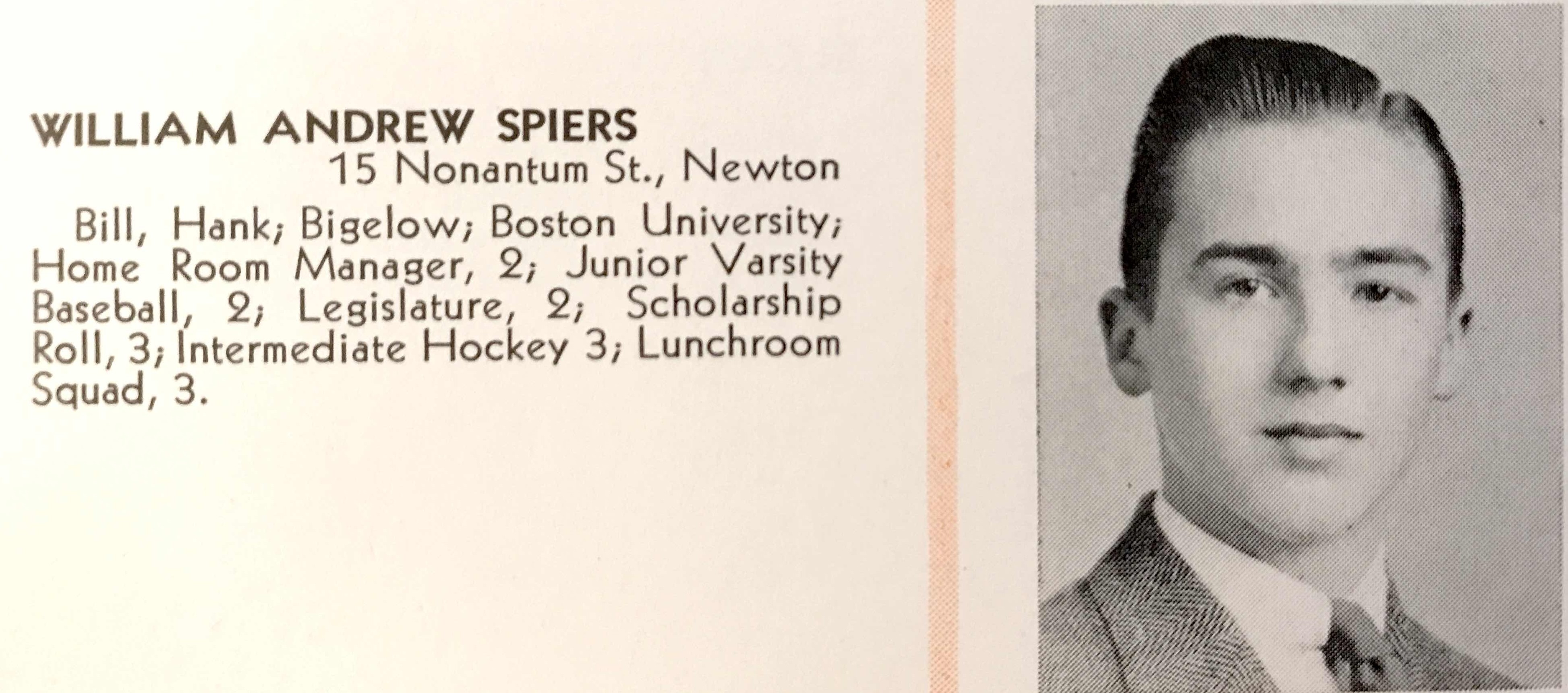
Frederick H. Timson, Jr. (1906-1945) PVT, USAAF
Nicholas Tocci (1920-1945) PVT, US Army
Hugh Van Roosen (1922-1943) LT(jg), USN, Annapolis (Navy Cross)
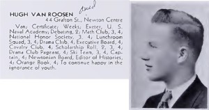
Hugh Van Roosen for whom Van Roosen Rd is named. B1922 G1938 D1943
Paul H. Van Wart (1922-1945) SGT, USAAF
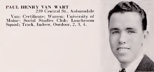
George E. Walsh (1906-1945) PVT, US Army
Frank W. Young, Jr. (1912-1944 ) SGT, US Army